Bogs, marshes, and swamps all tend to be associated with muddy connotations. However, these saturated areas are beautifully diverse wetlands that are crucial for maintaining the hydroecological health of a landscape. Importantly, they provide sanctuaries for migrating wildlife as well as control and purify water as it flows across the landscape. Natural wetlands are ecological, biogeochemical, and hydrological hot spots yet continue to disappear under human pressure.
Our group recently published two papers (here and here) that advance our understanding of how to accurately identify where wetlands should be in the landscape. This information is important for wetland protection because “where wetlands should be” can be compared to observational data of “where wetlands are” to prioritize the location of wetland management and protection measures.
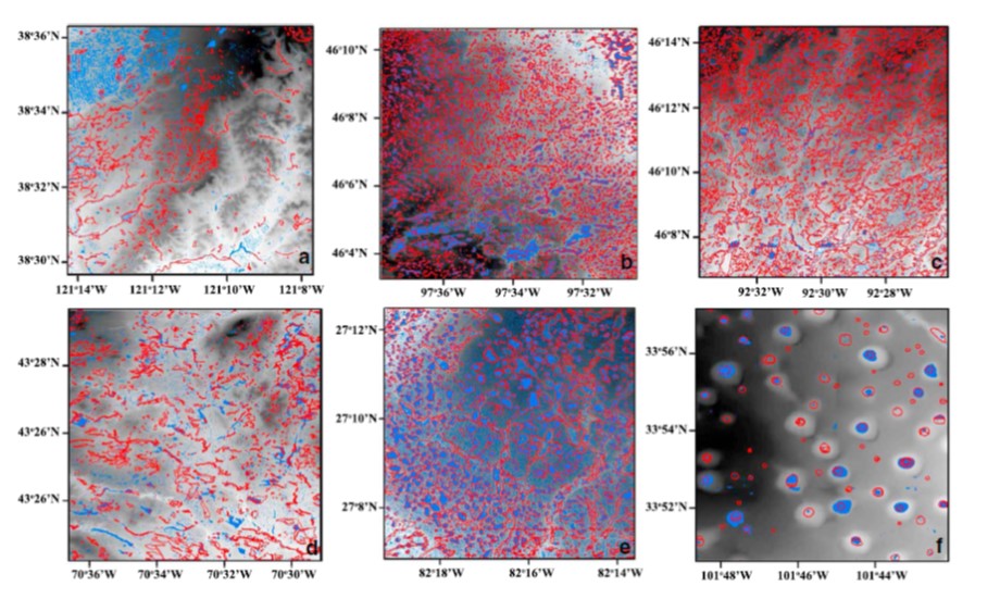
Our paper Wetlandscape fractal topography in Geophysical Research Letters (here) proposed that topography alone can reveal the location of wetlands. We also hypothesized that the (statistical) distribution of the (potential) wetlands identified from elevation data would be identical to the distribution of actual wetlands. We used a topographic depression identification model to delineate potential wetlands in six 10 × 10 km landscapes across the United States and compared the modeled wetlands to real wetlands cataloged in the National Wetland Inventory. The distribution of shapes and sizes were similar for both potential and real wetlands, indicating that topography data alone can be used to identify wetland properties. Widely available elevation data may thus be used to guide surveying and management when inventories are scarce. The apparent universality of the observed scaling could help managers and stakeholders preserve the fundamental properties of wetlandscapes.

Representation of the digital elevation model (grayscale background) of six 10 × 10 km landscapes and actual wetlands (red lines) from the National Wetland Inventory database: California vernal pools (a), North Dakota prairie potholes (b), Minnesota basin wetlands (c), Maine vernal pools (d), Florida cypress domes (e), and Texas playa lakes (f). The blue polygons represent the potential wetlands identified by the topographic depression identification model.
Our paper Stochastic modeling of wetland-groundwater systems in Advances in Water Resources (here) proposed that the statistical properties of wetland water storage can be described simply based on only three key factors: hydrologic connectivity to shallow groundwater, wetland bathymetry, and stochastic hydro-climatic forcing. We derived analytical expressions for the steady-state probability density functions (pdfs) for wetland water storage and stage using a small number of physically-based parameters. We showed that it is crucial to account for shallow groundwater connectivity to fully understand the hydrologic dynamics in wetlands. We successfully applied the new framework to two different case studies in Florida.

Schematic representation of the wetland-groundwater coupled model.

Comparisons between measured and modeled (A) temporal patterns of rainfall and normalized water volume in a wetland in the Lake Okeechobee basin, and (B) pdfs of the wetland stage W*.